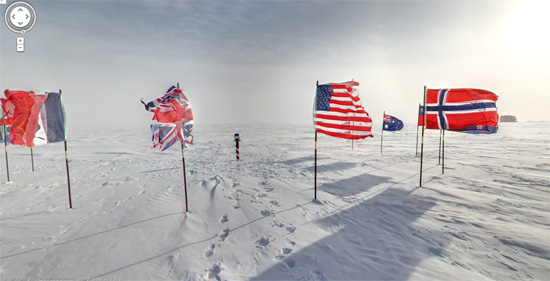
You Can Now Tour Historic Antarctica from Home With Google Street View
Google could already take you to some pretty amazing places with Google Maps, but their World Wonders project has upped the ante with remarkable locations from across the globe accessible to anyone with an Internet connection. Now Antarctica, once considered the last frontier, can be wandered with street view. But more importantly: There are penguins.
In truth, Google has had extremely limited street view imagery of the Antarctic available for nearly two years. However, this new batch of photographs focuses on historical locations around the most inhospitable land on Earth. Users can now walk up to the Ceremonial South Pole; explore the huts of great Antarctic explorers like Ernest Shackleton and Robert Scott; marvel at the South Pole telescope; and squeal with delight at the flightless denizens of the Cape Royds Adélie Penguin Rookery.
While penguins are a tough act to beat, the explorers’ huts are truly remarkable. Apparently preserved exactly as they were when their owners returned to civilization, the rooms are filled with artifacts and are in startlingly good shape. It’s a peek into the day-to-day lives of these storied explorers.
In order to get these pictures, Google had to use some different tricks. From street view technical program manager Alex Starns’ blog post:
This new imagery was collected with a lightweight tripod camera with a fisheye lens—equipment typically used to capture business interiors through the Business Photos program. We worked with this technology because of its portability, reliability and ease-of-use (our Street View trikes wouldn’t be much use in the snow).
For those of us sweltering in this summer heat, the opportunity to even look at some snow (and penguins!) is a welcome one. Viewers can marvel at the desolation either from Google Maps or their World Wonders website.
- More on Google’s World Wonders project
- This is an ocean beach in the middle of a field
- The dark side of Google Maps
Have a tip we should know? [email protected]
